 Examining land ownership at Indian Camp
Grades/Level: Middle School (7-9), High School (9-12)
Subjects: Social Studies, Language Arts
Time Requirement: 90 minutes Homework: Short expository post-activity writing.
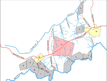
Overview: Students will engage with changing land ownership at the Indian Camp plantation from 1710 through 1770, revieving an interactive map, and related primary documents. The broad questions are: How did rivers and roads affect development? What was the effect of land fragmentation and family ownership on the building of community, for both the land owners and their enslaved workers?
Pre-writing: How do we learn about the past. Discuss where historical documents can be found and what they can tell us.
Activity: Students will discuss modern records (wills and land ownership and how those records persists and can inform us about the past.
Post-writing: Students will write a piece discussing how ownership of the land changed over time and how these changes might have affected slave families.
Learning Objectives:
Understand historical documents as providing information about the growth of community and land patterns in Virginia.
The lesson:
Collaborating in small groups, ask the students to to discuss and write a summary of what they see in the module
The roads and rivers give clues to why land might have been settled as it was, but the larger intent is to show change and see what the cultural landscape of the people living in these communities might have been: who were their neighbors, what other properties might people have had access to. The scope of the study, forty years, lies within the scope of a single lifetime. For those people brought to work on the plantations who else might they have known, met and worked with? How did the land changes play a part in building or destroying community though land sales, deaths and partitions of land?
Transition:
Ask the students to access the interactive module. Explain the step (next and prev) and play controls. What is happening on the map.
For a given year ask them to list some of the land owners.
HOOK: What are some of the names in the documents? Does anyone in the class know someone with those names? How does land ownership persist today?
Collaborating in small groups, ask the students to to discuss and write a summary of what they see in the module, answering the following questions:
- How does landscape change?
- Where did people first settle?
- What pieces of land are most desirable early on?
- How does landscape develop?
Other Materials:
- Interactive Module (opens in a new window)
- One page general overview of the context of the historical time in Virginia
or download PDF copy - Surveyors Chain
- Maps indicating the tidewater, piedmont, and mountain areas of Virginia (download PDF copy)
- Land and Community - An Interactive Educational Module - conference paper
